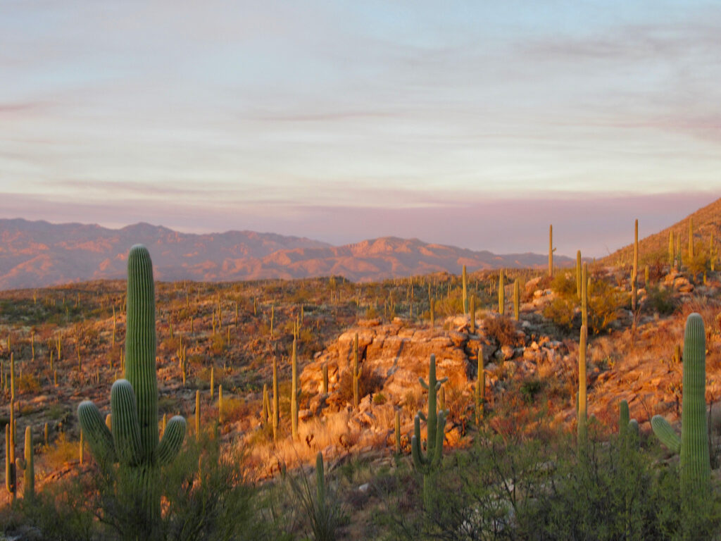
Which side of Saguaro National Park is better – east or west? Why are the two Saguaro National Park districts separated by the city of Tucson, Arizona? What is a saguaro, anyway? This post is all about questions and answers.
Disclosure: This post contains affiliate links. If you buy something from one of our affiliates, we receive a small commission at no extra charge to you. Thanks for helping to keep our blog up and running!
Table of Contents
Introducing Saguaro National Park
Did you know that Tucson, Arizona and environs are home to the largest cacti in the United States?
It’s true!
Giant saguaro cacti (Carnegiea gigantea) are only found in a small portion of the US. They were first protected when Herbert Hoover declared an area east of Tucson as the Saguaro National Monument. Almost 30 years later, Saguaro National Monument West was added.
In 1994, Congress officially declared the area a National Park to help protect the saguaro – an icon of the American west.
What’s the Difference Between a National Park and National Monument?
National Monuments can be designated by the President of the United States, but National Parks require an Act of Congress to establish. Want to know more about Arizona’s National Monuments? Check out these other posts:
Visiting Arizona’s National Monuments in Spring
Organ Pipe Cactus National Monument
Exploring Chiricahua National Monument

All About Saguaro Cactus
- How do you pronounce the word “saguaro”?
Sa-WAH-ro - Where is the tallest saguaro?
Topping 78 feet (23.7 m), the tallest ever recorded sadly toppled over in 1986. Tall saguaros can be seen today on the Loma Verde loop in the East District, but there is no one saguaro designated as the tallest. - How fast do saguaros grow?
Slowwwwww-ly. A saguaro grows between 1 to 1 ½ inches (25-38 mm) in the first 8 years. - How long do saguaro live?
They can live up to 250 years. - When do saguaros bloom?
Late April to June is the flowering season for saguaros. - How much do Arizonans love their saguaro?
The beautiful white bloom of the saguaro cactus is the Arizona state flower.
Saguaro National Park: East versus West
So which side of Saguaro National Park is better – east or west? It depends on what you want to see and do. There are differences and similarities between both districts.
What are the differences between east and west Saguaro National Park?
- Size. East Saguaro – Rincon Mountain District – is 67,476 acres (27,306 ha). West Saguaro – Tucson Mountain District – is only 25,391 acres (10,275 ha).
- Miles of hiking trails. East Saguaro has 128 miles (206 km) of hiking trails – and the Arizona Trail cuts through this rugged district. West Saguaro has 43 miles (69 km) of established trails.
- Camping opportunities. The Rincon Mountain District has 6 backcountry sites – walk in only. The Tucson Mountain District has no camping facilities.
- Number of picnic areas. West wins with 5; east has 2.
- Date established. Saguaro National Park East was established in 1933. West Saguaro came along in 1961.
- Tallest mountain. The Rincon Mountain District is rugged. Mica Mountain tops out at 8,666 feet (2641 m). The Tucson Mountain District of Saguaro National Park has Wasson Peak, reaching 4,687 feet (1428 m).
- Saguaro. Saguaro National Park East has an older saguaro forest. The west district has a higher saguaro density – and a younger saguaro forest.

More than Saguaro Cactus
Saguaro cactus are the largest and most obvious cactus, but did you know that Saguaro National Park is home to 25 different species of cactus? Nope, neither did we until we visited! The Sonoran Desert is rich in biodiversity.
What are 6 common cacti found within Saguaro National Park and environs – not including the namesake species?
- Fishhook barrel cactus
- Staghorn cholla cactus
- Pinkflower hedgehog cactus
- Engelmans’s prickly pear cactus
- Teddybear cholla cactus
- Chainfruit (Jumping) cholla cactus

What are the Similarities between East and West Saguaro National Park Districts?
Both districts of Saguaro National Park have their own visitor center, open daily 9 am – 5 pm. Both Red Hills Visitor Center in Saguaro West and Rincon Mountain Visitor Center in Saguaro East provide restrooms, water fountains, maps, and interpretive programs. There are no hiking trails starting from either visitor center.
Both districts offer programs including indoor presentations, patio talks, short, guided walks, and guided hikes varying in length and topic. Each district has a scenic driving loop. Neither loop is suitable for vehicles over 35 ft (10.7 m) in length. Bike riding is limited in both East and West Saguaro. Both districts have a variety of short and long hiking trails.
Where can you hike in Saguaro National Park?
Saguaro National Park’s two districts offer more than 165 miles (264 km) of hiking trails. You can take a stroll on a short interpretive nature trail or a head out on a day-long wilderness trek. We tend to hike somewhere in the middle!
Stop in at one of the visitor centres for details on other hikes, but our recommendations include:
- Tanque Verde Trail in Saguaro East. It may be a tad steep and strenuous – but oh… those views! As an out-and-back hike, you can go as far and as high as you want. Consider this a full-day hike.
- Bridal Wreath Falls – looping back on Carrillo and down Wildhorse – is an awesome half-day hike to a beautiful, high desert waterfall. It’s also a Saguaro East hike.
- Wasson Peak – a must-do in Saguaro West! Although part of the loop we take is in Tucson Mountain Regional Park, much of the hike is in the national park. Start at King Canyon and head up to the summit before coming down the Hugh Norris trail and hitting Gould Mine for a loop back to the parking lot. This is a longer half-day hike.

Where can you bike in Saguaro National Park?
In the Rincon Mountain District, you can only bike on the 8-mile (12.8 km), paved, Cactus Forest Loop drive, the 2.5-mile ( km) Cactus Forest Trail, and the 2.8-mile (4.5 km) Hope Camp Trail. Note: bikes are allowed on the Arizona Trail.
Mountain bikers can ride the 6-mile (9.6 km) Bajada Loop scenic drive in the Tucson Mountain District. The Golden Gate multi-use trail – an old road – off the Bajada Loop is also open to bikes. Both routes are gravel.
Nearby, check out cycling the Arizona Trail.
Is Saguaro National Park worth visiting?
In a word, yes.
Definitely.
Absolutely… okay, three words!
Which side is better – east or west? It’s up to you to decide! Both have their own special appeal.
All I know is that when you are in Tucson, be sure to visit Saguaro National Park. East or West or both sides – it really doesn’t matter! Just go and prepare for the delight of a giant cactus forest unlike anything you’ve ever seen.

When You Go
- Saguaro National Park East and West are separated by the City of Tucson. It takes approximately 30-45 minutes to travel between the two districts, depending on route and traffic.
- You will need a valid National Parks Pass to enter. We always buy an annual pass, but if you buy the 7-day pass, it’s good for both East and West Saguaro.
- Where to camp? In the east we like Cactus Country RV Resort. In the west we chose Gilbert Ray Campground in Tucson Mountain Park.


Read with interest since we leave Monday 20 March for a southern AZ and NM sojourn. We will be staying near Saguaro NP East but have dogs. Are there easy walking trails in the East District
Like most national parks now, dogs are allowed only on roadways, picnic areas and paved trails in Saguaro National Park. In Saguaro NP East, check out Mica Trail. It’s paved, 0.7 miles one-way is an easy walk.
How many miles are the two parks separated by? Hard ti find the answer!
It’s about 31 miles (approximately) between Saguaro East and Saguaro West. Enjoy your visit – both sides are amazing!