It’s this time of year that we start planning spring paddling adventures. Alberta canoe trips rank high on our list of things to do. This spring we’re hoping to take friends for their first time paddling the Milk River. It is one of the best canoe trips in Alberta – if you know what you’re doing and have the right gear!
Disclosure: This post contains affiliate links. If you buy something from one of our affiliates, we receive a small commission at no extra charge to you. Thanks for helping to keep our blog up and running!

Table of Contents
Adventures Along the Milk River
We love canoe tripping in Alberta. Most of our paddle adventures go off without a hitch. Our first trip paddling the Milk River years ago was a little more memorable. We were travelling with a ragtag group of friends and acquaintances. Right out of the chute, one of the boats was attacked by a rock. The rock won, puncturing a hole in thinly patched fiberglass. Water shot up through the wound like Old Faithful! The hole was too big to repair.
Fortunately, we were less than ½ a kilometer downstream and there was still a place for them to get off the river and retrieve their vehicle. Had it happened farther downstream it would have been more of a crisis. There are some places where there is simply no way to get off the river. Down one family and their boat and gear, we said our goodbyes and paddled on.
Friends had invited their friends who had never paddled before. On one of the first tight corners, they hit a rock, became high-centered, spun around and sat there for a moment before sliding off the rock and going backwards downstream. It seemed prudent to put them in separate boats with new captains after that.
We paddled, camped, explored Gold Springs Park and watched for swallows in cliff nests. River life clicked in and we had found our collective groove. And then we entered another rocky set of S-curves in the river below Coffin Bridge.

River Rescue
Two bedraggled men wearing life jackets and soaking wet blue jeans were standing on the corner. One was waving frantically with a wooden paddle.
“Stop,” they yelled. “It’s dangerous!”
We pulled out one by one and, as we did, we glanced downstream. That’s when we saw their canoe. Or what was left of the vessel wrapped around a mid-stream rock. Turns out the pair in their mid-60s were on a day trip down the river from Coffin Bridge to Writing-on-Stone Provincial Park. They didn’t have a lot of experience paddling and the sharp corner and big boulder were too much for them to handle.
Miles from anywhere, the only way they were getting off the river was with us. One of the men said he needed to get his cooler bag out of the wrecked canoe before we left. It had his heart medication in it!
Lucky for them, we had a couple of strong paddlers and Park Rangers with river rescue experience in our group. The medication was retrieved, and we reorganized our boats to make room for two more passengers. We stopped at Poverty Rock for a lunch break. It took several minutes to get one of the guys out of our canoe – his body had stiffened up after being beaten against the rocks during his untimely departure from his own boat.
After our break, we paddled down to Weir Bridge where we were able to get up out of the river bottom and find some cell phone coverage. Here, the guys called their wives to pick them up. Before leaving, one of the men turned to our daughter and gave her his wooden paddle.
“You can have this,” he said. “There’s no way my wife is ever going to let me get in a canoe again!”
Love reading about travel misadventures?
Check out “I’ll Never Pee in the Woods Again!“
Where is the Milk River?
The Milk River actually starts in Western Montana. It crosses the border and meanders through southern Alberta for some 160 kilometres before it heads back into the United States. From here, it flows into the Missouri, which then empties into the Gulf of Mexico. The Milk River is the only watershed in Alberta that drains south to the Gulf.
Did You Know? The Milk River was named by the Lewis & Clark Expedition in 1805-1806. But long before that, peoples of the Blackfoot Confederacy called it Kiina’kssissa’ahta (Little River).
Common Plants and Animals of the Milk River
The Milk River are is known for its dry climate. Plains cottonwoods grow along the river bottom east of Poverty Rock. Wolf willow, saskatoon, chokecherry, buffaloberry, sagebrush and prickly pear cactus are all common plants found along the canoe route and in the coulees. Off the river, grasslands abound.
Wildlife sighting can include pronghorn, whitetail deer, mule deer, coyotes, badgers, yellow-bellied marmot, beaver, cottontail rabbits, rattlesnakes, bull snakes, garter snakes and northern leopard frogs. Hawks, eagles and falcons fly overhead while songbirds sing from treetops and fenceposts. There is a good bird checklist from Writing-on-Stone Provincial Park that may come in handy if you’re a birder.
Paddling the Milk River
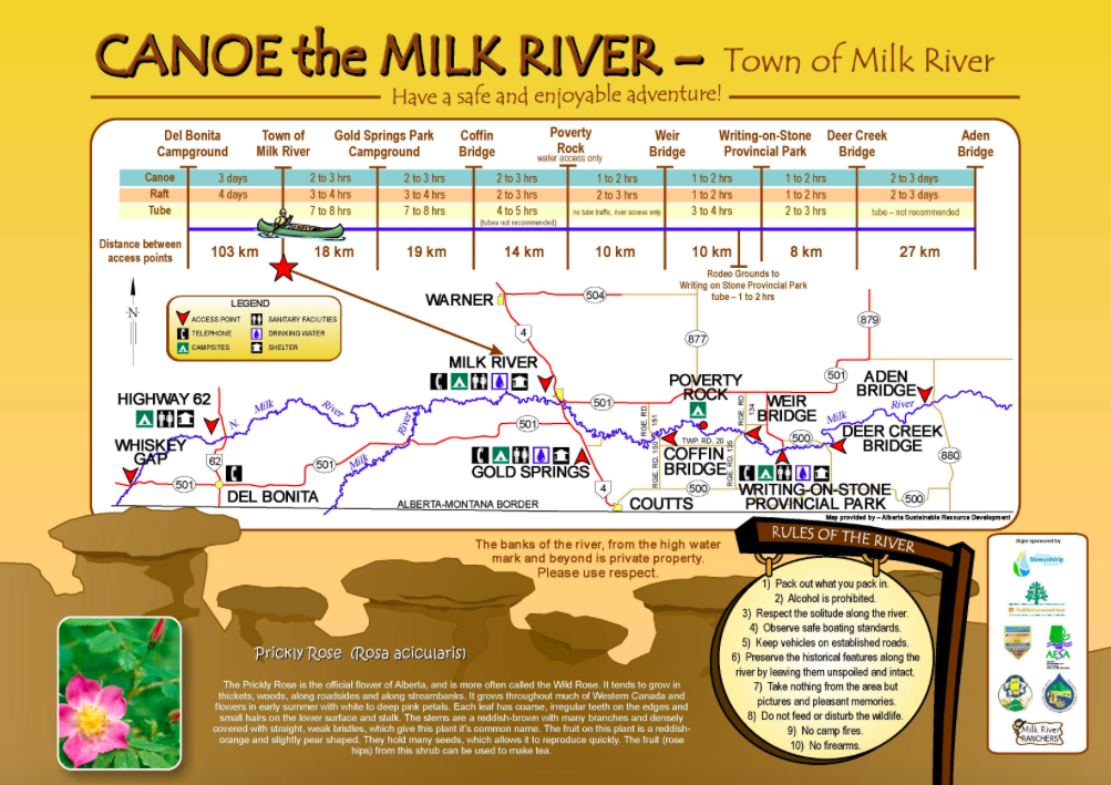
Most people paddle the stretch from either the townsite of Milk River to Writing-on-Stone (WOS) Provincial Park or Gold Springs to WOS. It is 71 kilometres from Milk River to WOS. You can shave 18 kilometres off that distance by starting at Gold Springs Park Campground. It is possible to paddle the stretch above Milk River from Del Bonita (103 km) if the water levels are high enough.
Whichever stretch you choose, you will need to set up a vehicle shuttle so that you have a vehicle at your takeout point. There are several companies that used to offer shuttle service for those groups with only one vehicle (check resources at the end this post).
Camping
There are four official campgrounds along the most popular stretch of the Milk River for paddling. The first is the 8 Flags Campground at the put-in point in the Town of Milk River. Downstream is the Gold Springs Park Campground, followed by Poverty Rock and Writing-on-Stone Provincial Park at the take-out point. Access to Poverty Rock is by boat only. Camping is also allowed along the river below the highwater mark. Above this is private property.
Need camping gear? Shop all deals at Mec.ca!
Did You Know? The term “Under Eight Flags” comes from the fact that the flags of the Hudson’s Bay Company and the Canadian Red Ensign (de facto national flag of Canada from 1868-1965) and the flag of six governments (France, Spanish Empire, French Republic, United States, British Empire and Canada) have all flown in this Alberta watershed at some point in history.
Leave No Trace
It should go without saying, but sadly we’ve seen plenty of evidence left behind from other river users that says Leave No Trace ethics are not always the norm. Plan ahead and prepare to lessen your impact. Camp on durable surfaces. Dispose of waste properly. Leave what you find – this one is key along the Milk River with its rich archaeological history. Minimize campfire impacts – in fact, I’d go so far as to suggest don’t plan on having a wood-burning campfire anywhere along the river except for established campgrounds. Be considerate of others – and respect private property.
River Safety
Weather changes frequently – and you need to be prepared for wind and rain on every trip – but you can get an idea of the long-term forecast before you go. We like the Environment Canada forecast. Water levels fluctuate on the Milk River. The river is best paddled between 15-25 m3/s. Check Alberta Rivers for latest flow information.
Some people consider the Milk River to be an an easy river to paddle. Winds and high water can easily change the conditions. Some sections of the river are quite remote and difficult to access. The section between Gold Spring and Weir Bridge has numerous rock gardens, hidden boulders and overhanging cliffs. The two gentlemen in our Milk River adventure might have benefited from taking a canoeing course or at least taking this Paddlers Self-Rating Guide!
Get the Gear
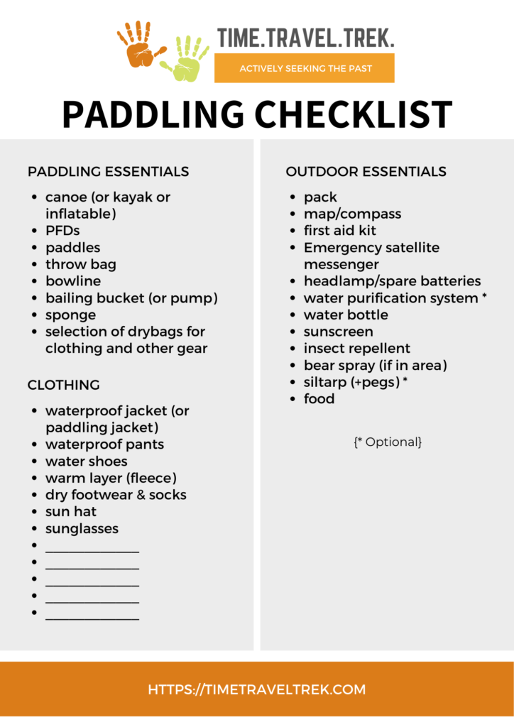
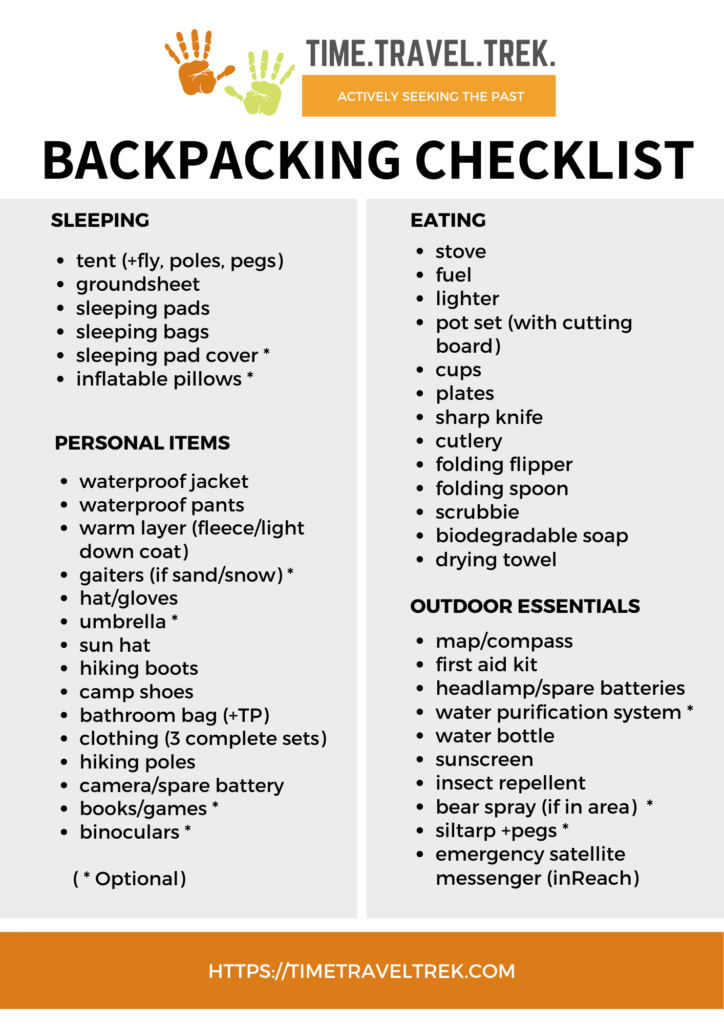
Every boat needs a throw bag, bailer and extra paddle. Each person needs a Personal Floatation Device (PFD) and whistle. Groups should have all of the necessary maps, camping, personal and emergency gear (e.g. first aid kits, emergency satellite messaging device such as the Garmin InReach…). Use our checklists in the additional resources section below to help you get started.
Additional Resources
Aquabatics Calgary is an online paddlesports store (part of AQ Outdoors) with all the paddling gear you need!
Paddle Alberta has a list of shuttle services operating on the Milk River. Brad and group of his buddies used Karen’s Canoe Service from Del Bonita when paddling the upper section of the Milk (and recommend it).
The Milk River Watershed Council Canada has a lot of additional information and reports on their website.
Looking for other paddling adventures in Alberta? Check out Paddling the Red Deer River or Canoeing the South Saskatchewan: Medicine Hat to Sandy Point or Canoeing the Oldman River: Monarch to Lethbridge.
PIN THESE CHECKLISTS FOR FUTURE REFERENCE!


Hi Megan, I know 2020 was a no-go for paddling the Milk because of an issue with a dam in Montana – is that resolved for this year? TIA!
Yes! According to my source, the diversion repairs are now complete and snow pack is above average in the upper St Marys (which feeds the Milk River). All this means 2021 is looking good.
Hey, Megan, Ken suggested I start researching the Milk and I stumbled upon your blog. Nicely done — thanks for the tips! Hope to see you again soon.
Welcome to the blog, Jeremiah. Glad you found the tips useful. I’m sure we’ll see you on a river one day soon!
Thanks for the report – very helpful. We’re experienced canoeists and have a plan to go this next week. The flow rate is at 32m^3/s right now – quite high – would you have any concerns about this flow level? I’m thinking the trip will go quite fast and that we might be able to go to Poverty Rock from Milk River in one long day.
Hello Guy – glad you found this post useful. The Milk River from Poverty Rock to Writing-on-Stone is much less technical than the upper section. It should be not much of an issue at higher levels for experienced paddlers. The upper section from Milk River to Poverty Rock could be tricky depending on flow. High water also makes take outs more challenging.
Hey we want to kayak the milk river this weekend, how long does it take from the townsite to writing on stone csmpground
Depends on your skill level, weather forecast and river flow for starters. It’s 71 km with quite a bit of technical manoeuvring in upper section. I wouldn’t try doing this 71 km distance in a weekend myself.
Hello,
Great blog! My daughter and I are planning a trip and want to paddle in a dori (fly fishing boat) is the Milk River accessible for these type of boats?
I’ve never paddled a dori before, but there are quite a few midstream rocks to avoid and sharp turns to navigate in the upper section from Milk River.