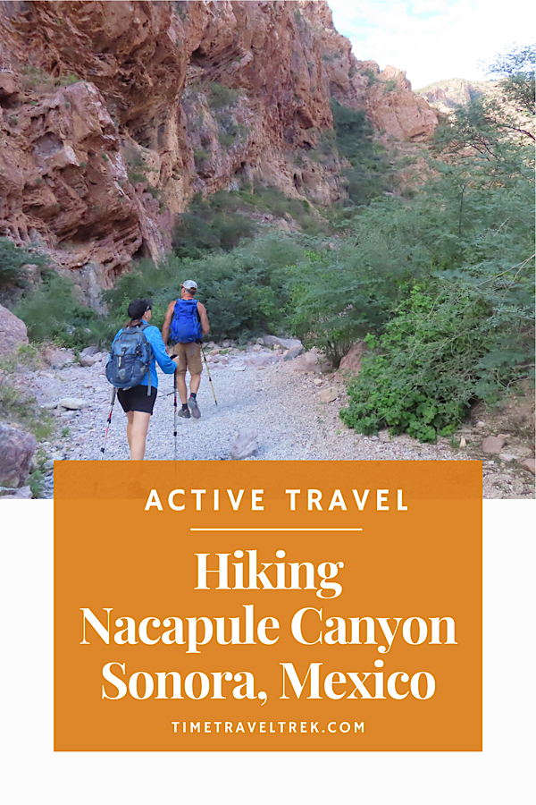
Hiking Nacapule Canyon – whether you opt for a short stroll up to see the palm tree forests or scramble all the way to the eye of water – is a must-do for anyone visiting San Carlos, Mexico.
This is the 4th post in our series San Carlos, Sonora: An Active Basecamp on the Sea of Cortez, where we explore RV travel, paddling routes, hiking trails, biking loops and so much more. Be sure to catch the whole series before you start planning your own trip!
Table of Contents
Nacapule Canyon Hiking Adventure
If you’ve been following along in this San Carlos series, you’ll know we’ve already set up camp in Totonaka RV Park and paddled quiet waters kayaking the Soldado Estuary. Our friends insisted we need to take a day and trade ocean views for desert cliffs and palms.
“We need to hike Nacapule,” they said. “It’s short—but amazing.”
Our friends were determined to prove that San Carlos had all the biking, hiking, and paddling adventures we love. After kayaking the estuary, we checked one box. Now it was time to see if a desert canyon could truly surprise us.
Nacapule (pronounced Nack-a-pool-eee) is the best-known of eleven canyons in the rugged Sierra El Aguaje. These mountains were born during the Cretaceous period—about 145 million years ago, when dinosaurs still walked the earth. Today, they rise in layers of red and rust, streaked with quartz and volcanic rock. Interpretive signs along the trail invite you to look for geodes, obsidian, and caves tucked into the cliffs.
The canyon begins gently. A sandy path leads into a narrow corridor of towering red rock walls and swaying palms. Freshwater springs create a surprising microclimate here—lush, humid, and green compared to the surrounding desert. More than 285 plant species and roughly 100 bird species have been recorded in this canyon ecosystem.
Even on a quiet morning, it feels alive with promise.
Like keeping track of your list and wish list rides?
Pick up a copy of our printable Hiking Journal in our Etsy shop!

Easy Stroll Along Sendero Cholugo
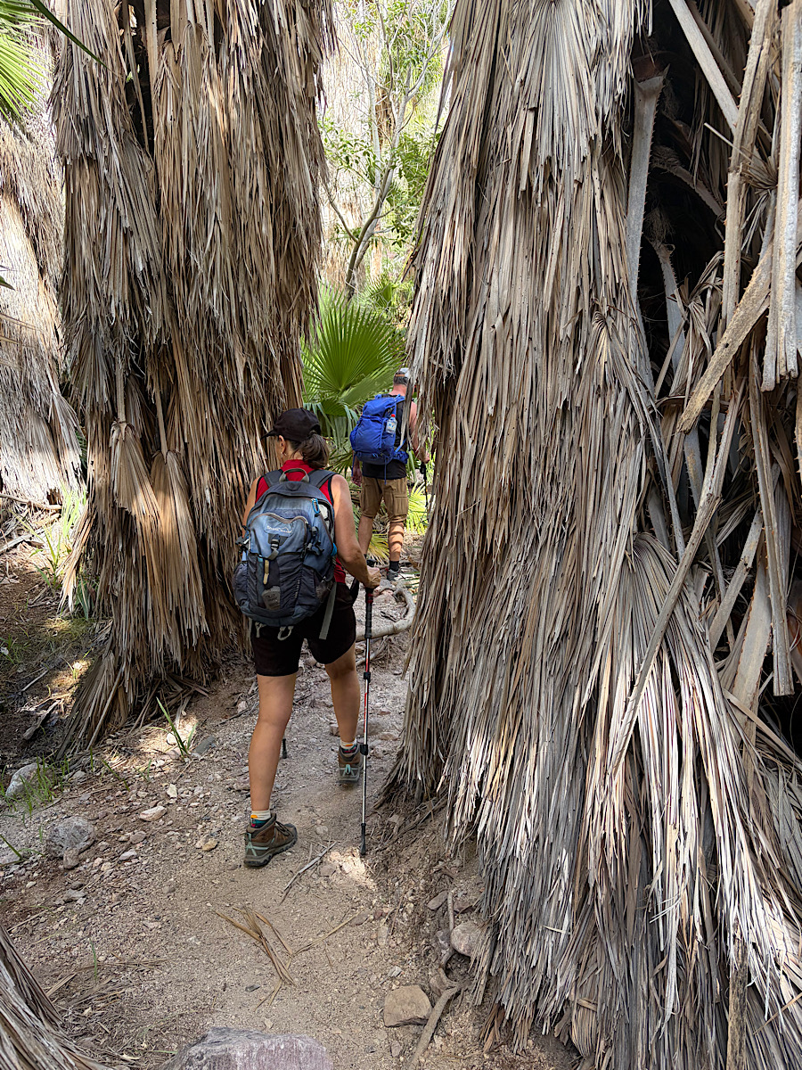
At the trail junction, signs point to Sendero Cholugo and Sendero Ojo de Agua. Start with the shorter Sendero Cholugo. It’s a 200–300 metre side canyon that winds through dense palm forest toward a cave and an enormous Nacapule tree.
The Mayo and Yaqui people named the Nacapule tree; in the Cahita language, “nacapule” means earlobe. Its thick trunk and broad leaves hint at its tropical origins, and its seeds feed bats and birds that inhabit the canyon.
Normally, this shaded stretch would be prime birding habitat. We expected chatter overhead, but the morning was unusually still. The only sounds were a single canyon wren echoing off the rock walls and the distinctive tapping call of a Gila woodpecker somewhere above us.
The path climbs slightly toward a rock cave, and while rougher tracks continue higher along the canyon wall, we turned back—saving our energy for the main event.
Scramble Up to Ojo de Agua
Back at the junction, we headed up Sendero Ojo de Agua.
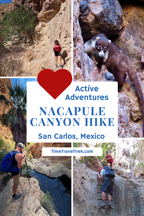
From here, the hike gradually becomes more adventurous. The first 1.1 kilometres lead up the canyon floor toward a dryfall and ladder. Along the way, we crossed boulder fields, navigated sidehills, and picked our way through narrowing rock corridors.
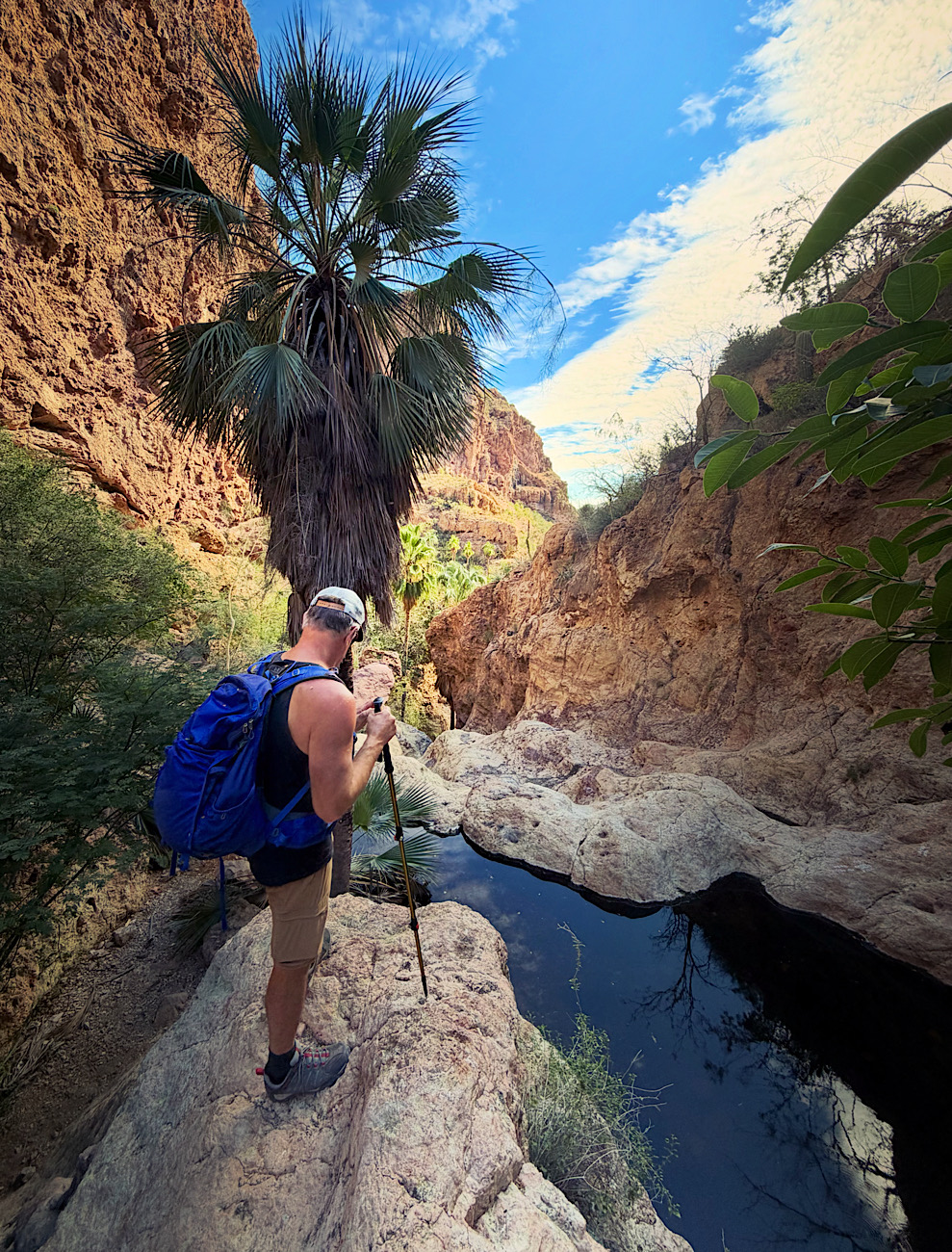
The ladder climb is short but exciting—a steep ascent beside a dry waterfall, with a rope at the top to help with the final pull. Above it, the canyon changes character. The rock deepens from pale sand to a dramatic rusty red, and the scrambling becomes more frequent.

About 0.5 kilometres farther up, we reached the first pools—dark, still water collected beneath towering rock walls. These “ojos” (eyes) are fed by water that seeps and travels underground through volcanic layers before emerging here. Some pools depend on the rainy season; others persist year-round.
We continued to the final pool near what we called the Coati Rockwall. And that’s where the hike delivered its wildest moment.
A coatimundi appears.
It isn’t shy. In fact, it walks straight toward us, clearly habituated to hikers. We shooed it away gently, a reminder that while this canyon feels remote, wildlife here has grown accustomed to visitors.
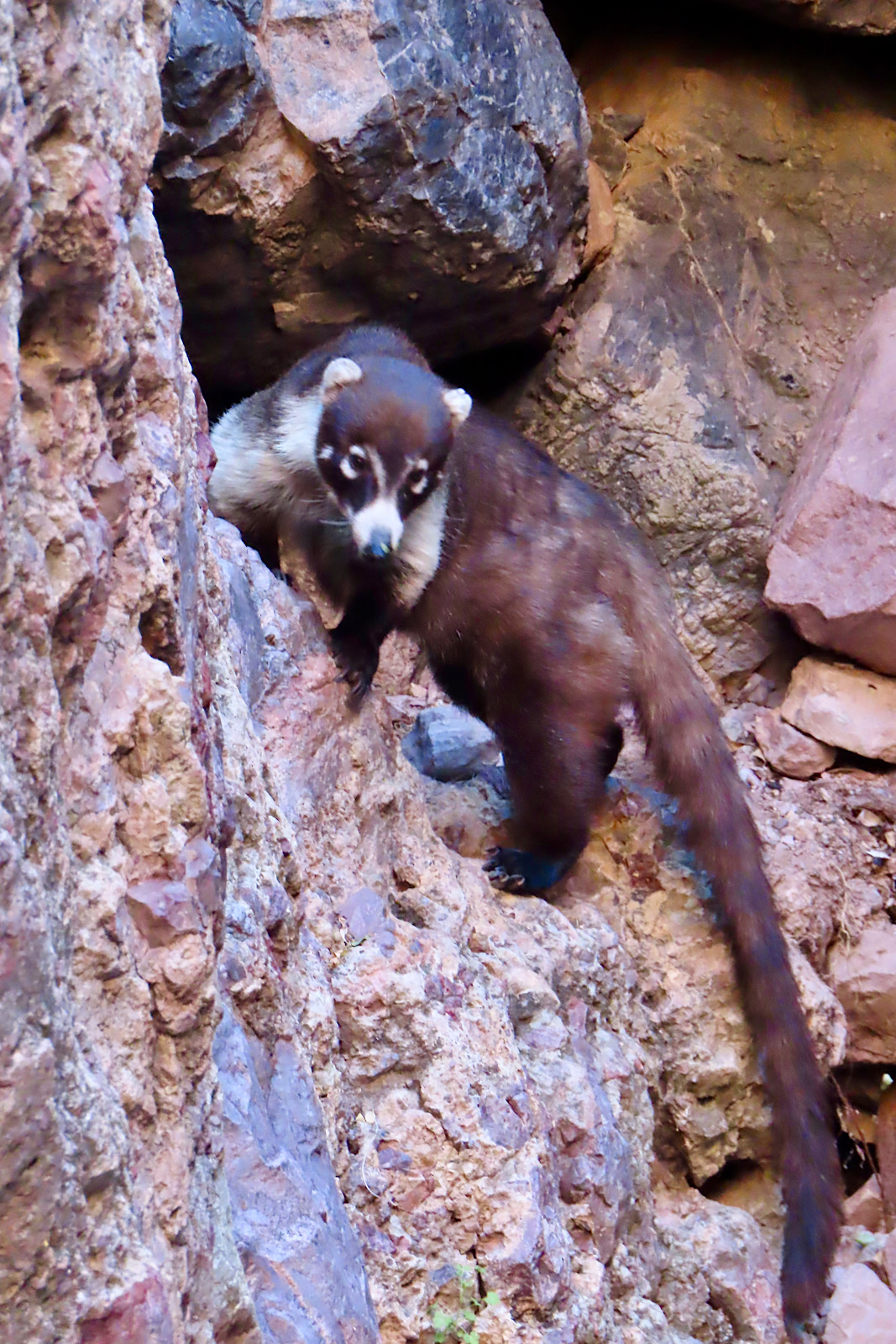
What is a coati (aka coatimundi)?
A coati is an omnivourous animal that feeds on fruits, insects, and small vertebrates. It is native to Southern and Central America. Coatimundis can range up through Mexico into southern Arizona at areas such as Patagonia Lake. They are part of the raccoon family and are known for their long snouts, striped tails and sharp claws.
Why do this hike?
Nacapule Canyon surprised us. It delivered palms in a desert, freshwater in volcanic rock, and just enough scrambling to make us grin. It’s a compact adventure that feels far bigger than its mileage suggests.
Hiking Nacapule Canyon is a must-do for anyone visiting this corner of Sonora. Whether you stroll beneath palm forests or scramble all the way to the pools of water tucked deep in the canyon, this is one of the most memorable adventures in town.
When You Go
How Far is the Nacapule Canyon Hike?
In total, the out-and-back distance is about 3.5 kilometres with roughly 190 metres of elevation gain. It begins as easy and finishes as moderate, with scrambling and light climbing required.
Love desert hikes? Check out nearby Tom’s Peak!
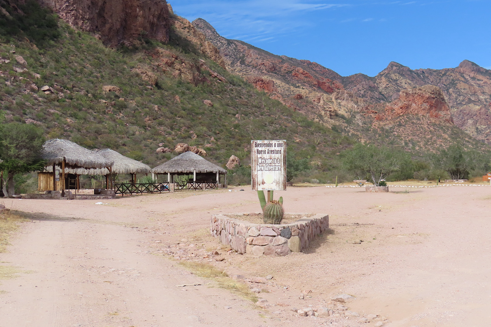
How to Get to Nacapule Canyon
From town, head toward the old airport runway area and follow signs toward Nacapule. The route winds through neighbourhood streets before becoming a bumpy dirt road. Occasiomal signs help mark the way, but it’s wise to download a trail map before you go, as signage can be limited in places. More detailed directions can be found on the What’s Up San Carlos website.
The canyon is typically open Tuesday through Sunday from 8 a.m. to 5 p.m. There is also a zip-line and adventure course operating on weekends.
Entrance Fees
There is a small entrance fee to park and hike (approximately 50 pesos per adult). Bring small bills or change.
What to Pack
- Plenty of water
- Lunch or snacks
- Good hiking shoes (essential for scrambling)
- Swimsuit if you plan to dip in the pools
- Hat, sunglasses, and sunscreen
- Binoculars for birding
- Camera
This is desert hiking—shade exists, but heat builds quickly.
Pin this post for future reference!
👉 Up next in the series: San Carlos Adventures: Kayaking Isla de la Raza
An easy day paddle right across from your basecamp!
Nacapule Canyon is one of those Sonora gems that most visitors to Mexico completely miss because they’re focused on the beach resorts. The hike through the slot canyon section is genuinely spectacular and the swimming holes at the end make it worth every step in the heat. Some reference imagery of Sonora landscapes: https://www.dreamstime.com/photos-images/sonora-mexico-landscape.html. Great hiking guide!
I agree Laura, the area is full of natural wonders!