Gila Box Riparian National Conservation Area is a unique river and creekbank habitat located near Safford, Arizona. This conservation area protects valuable natural and cultural resources. It also provides opportunities for hiking, biking, paddling, wildlife viewing, camping and more!
Disclosure: This post contains affiliate links. If you buy something from one of our affiliates, we receive a small commission at no extra charge to you. Thanks for helping to keep our blog up and running!
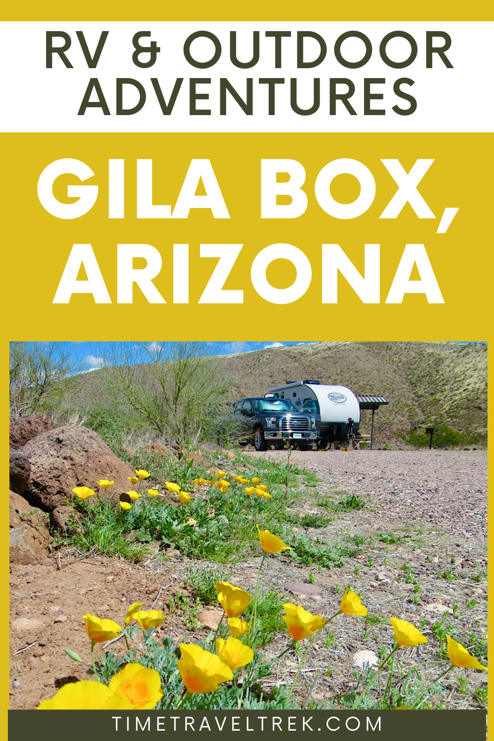
Table of Contents
Discovering Gila Box Riparian National Conservation Area
Sometimes I pull out the Arizona atlas and study the state for places we’ve never visited before. That’s exactly how I discovered Gila Box Riparian Conservation Area.
It was close, we’d never explored it, and it not only had hiking and biking potential but paddling opportunities as well.
Tick, tick, tick – time to go.

Plan your adventures with our 2026 RV Trip Planner available in our Etsy Printables Shop!
Quick Questions & Answers about Gila Box RNCA
- Where is Gila Box?
This protected area riparian gem is located along the Gila River in southeast Arizona near the town of Safford. - What does “riparian” mean?
Riparian refers to anything associated with, living on, or situated on the banks of rivers and creeks. - How do you access this Riparian National Conservation Area?
The most frequently used access points are at the east and west ends of RNCA – from the Clifton area in the east and Safford region in the west. - What makes Gila Box significant?
The Gila Box Riparian National Conservation Area includes four perennial waterways. This includes over 20 miles (32 km) of the Gila River, a short section of the San Francisco River, a small portion of Eagle Creek, and 15 miles (24 km) of Bonita Creek. - What is the importance of riparian areas in the desert Southwest?
Riparian areas are rare in the desert Southwest. They provide critical habitat for a variety of species including over hundreds of bird species. - How big is Gila Box RNCA?
This riparian conservation area covers over 23,000 acres (9,308 ha) of land.

Human History in Gila Box Riparian National Conservation Area
The area around Gila Box has a rich human history dating back thousands of years, with evidence of human presence dating back to prehistoric times.
The Hohokam people were among the first known inhabitants of the area. There is evidence of Hohokam presence dating back to 300 BC. The Hohokam people were known for their irrigation systems. This allowed them to grow crops in the arid environment of the region. Both Hohokam and Mogollan farmers lived in small stone house villages along the Gila and its tributaries.
Around 1275-1325, some Ancestral Puebloan people migrated from northeastern Arizona. They took advantage of the area’s more plentiful water and food resources. Sometime after 1600, Apaches hunted and farmed the region. The area was a well-known travel route.
In the late 1870s and early 1880s, Anglo-American and Hispanic settlers began to move into the region. A few of them establishing ranches and farms. The Gila River was a vital source of water for the settlers. They constructed dams and irrigation systems to support their agricultural activities.
During the 1870s, copper mining began in Morenci. In 1873 residents along Bonita Creek built a trail between Safford and Morenci to haul supplies to the mines. The Safford-Morenci Trail is located at the northern end of the national conservation area. The Gila River flows through the conservation are just south of the Morenci mine. Eagle Creek provides water for the mining operation at Morenci.
During the 20th century, the area became a popular destination for outdoor recreation. Bird watching and wildlife viewing, hiking, exploring, and camping are popular activities – and right up our alley.
Let the adventures begin!

Time for These Humans to Set Up Camp
There are two official campgrounds in Gila Box. Riverview is closer to Safford and has 13 campsites as well as a group picnic area. The road in is paved almost all the way but it is narrow and winding. The final gravel hill down into the campground can be a bit rough. Owl Campground – which is closer to Clifton – has 7 sites. It’s a good dirt road all the way off the highway.
We chose Riverview because the sites are first-come, first-served. There was a better chance of getting in here. Due to recent rains and cool temps, the river was running brown and high. Perhaps this is why the campground was less than half full.
Site #3 overlooking the river from a bluff above the riparian zone. It had a long access road lined with golden poppies. Setting up our home space for the next few nights, we paid the exorbitant camping fee – a whopping $5/night! We couldn’t help marvelling at the fact that this included ramadas, vault toilets, water, and garbage cans.
Hiking in Gila Box
Established hiking trails are few and far between in this national conservation area. The 2-mile (3.2 km) trail from the campground down to the group camp and up across the hill to the watchable wildlife platform area is scenic, if short.
The Bonita Creek Watchable Wildlife Viewing Area offers a bird’s-eye view of the low canyon below. Freemont cottonwoods, Arizona sycamores and willows provide a lush green cover for the over 100 species of birds that have been recorded here.

Early morning and later in the evening is the time to visit as it comes alive with birds. We heard everything from canyon wrens to cardinals, lesser goldfinches to Lucy’s warblers. It didn’t hurt to relax and spend a bit of time with binoculars hoping for a coati or bobcat sighting.
On the hike back to camp, sunlight bathed the hills with golden light. The stone monument honouring General Stephen Watts Kearny glowed brightly. We stopped to read the bronze plaque on the front.

In fall of 1846, General Kearny led soldiers from Sante Fe to take California in the Mexican-American War. With Kit Carson as their guide, the group camped at Bonita Creek. They explored the canyon, and restocked their larder by fishing and hunting before continuing along the Gila River.
The Serna Cabin on Bonita Creek
This stone cabin is a short jaunt down the road from the Watchable Wildlife Area. The cabin was originally built in the 1920s by two brothers, Simon and Ivaldo Serna. They homesteaded here, growing vegetables and raising goats and cattle.
The property changed hands numerous times over the ensuing years. It became a weekend retreat and then a line-shack for cowboys working cattle in the area. The building was abandoned in 1965.
In 1990, when the Gila Box RNCA was officially designated. The ruins of the cabin were stabilize. Using old photographs and historic construction methods, the walls, roof, and floor were rebuilt.
An archaeological survey of the property prior to reconstruction uncovered prehistoric artifacts. Mano and metate fragments and ceramic sherds indicated occupation around 800-900 AD.
Biking the Back Roads of Gila Box Riparian National Conservation Area
The next morning we were up bright and early and ready to tackle a bike/hike combo day. Trust me, I wouldn’t have done this if it wasn’t for my e-bike! Riding up the short gravel section out of camp, we turned right onto the paved road following it up to the junction with the West Bonita Rim Road.
The first section of the now dirt road is a little steep and rocky. It levels off a bit as it follows the course of the creek far below. Cows warily watch us cycle by. Cattleguards are crossed and before long we are at the junction for Lee Trail Road.
Down, down, one mile (1.6 km) steeply down the rocky, narrow road to the creek. Oddly enough there is a short concrete walkway leading to a vault toilet, a picnic table and garbage can. This remote site is a rough 7.5 miles (12 km) from our campsite!

Ditching the bikes in the woods, we wander on foot upstream. Shoes off/shoes on/shoes off as we crisscross across the surprisingly clear waters of Bonita Creek. Our goal is to find a prehistoric granary we’d read about in the information sheets from the BLM office.

It’s a bit of an Easter Egg hunt and while we think we found the spot. Sadly there was no evidence of prehistoric masonry walls. We other treats along the way, though. Nothing like watching a canyon wren sing; stepping on the dry mud beside a mountain lion track; and seeing beaver chewed sticks along the flood-ravaged creek bed.
Day 2 Ride to Orange Cliffs
Another afternoon we head out to find the Orange Cliffs marked on the map. Dipping down across Bonita Creek we head towards the East Bonita Rim Road and continue along to the signed “Orange Cliffs” side road. We cycle past blooming poppies, yellow wallflower, purple phalacia, white California chicory and scattered blue Desert Hyacinth.

At about 0.9 mile (1.5 km) down the Orange Cliffs Road, watch for the small rock cairn on the left. It marks a good viewing point of the cliffs and the river below. The road dead ends after 1.2 miles (2 km). It offers good views of the Mount Graham complex towering to the southwest.
In total we biked 11.8 miles (19 km), saw 3 hikers with one dog and 5 cows. It was busy day in Gila Box!
Exploring Scenic Black Hills Byway
Rainy days with cool temps are often down time, but scattered showers with bits of clearing made it the perfect day to take a scenic drive and explore the other side of the national conservation area.

In 1915, construction began on the Old Safford-Clifton Road. Completed in 1920, this route provided shorter access to the Clifton/Morenci mining area. In 1992, this road was designated the Black Hills Country Byway.
Driving through the Past
We accessed the Black Hills Byway from the Clifton side, stopping at the info kiosk before descending to Owl Campground on the upper Gila River. Just below the campground, the historic 1919 Old Safford Bridge still crosses the river. Historic ranches, some passed down generation after generation, are passed.

Low stone walls are spotted as we climb up the hillside. Turns out these were built by the Civilian Conservation Corps (CCC) in the 1930s to provide erosion control. Climbing higher it becomes impossible to avoid seeing the massive mining tailings around Clifton and Morenci. We pull into a picnic area with covered ramada and interpretive signs. The signs discuss some of the richest copper deposits in the world and the largest copper mine in the Northern Hemisphere.
There are more than a couple hairpin corners as the road continues to climb up, up, up the dark volcanic rock of the Black Hills. Near the summit is Canyon Overlook, at a windy elevation of 5,500 ft (1676 m). On the other side, it’s down, down, down to the junction of the Black Hills Rockhounding area.
Ranching and Random Camping Around the Black Hills
An interpretive sign at the junction also highlights the historic Twin C Ranch nestled in the valley below. This remote ranch has been operated by Cipriano and Matilda Cueto – and more recently their descendants – since 1929. Imagine living at a what started as a dry ranch and hauling water 6 miles (9.6 km) from the Gila. You also needed to herd goats over to the river every 2-3 days so that they could drink.
Down off the hills, we passed a couple of dispersed campsites and the southern entry kiosk before popping back out on the highway. The route was 14.3 miles (23 km). It took us several hours.
Notes for Driving the Byway
- Speed limit is 15 mph (24 kph), but you’ll be lucky if you creep up this high!
- Signs suggest high-clearance vehicles, but the road surface was in excellent shape when we did it.
- Maximum vehicle length is 20 feet (6 m) and trailers and motorhomes are not recommended.
- Portions of the Black Hills Country Byway are narrow with steep drop-offs.
- This is a remote route. You will encounter few other motorists (we passed 2 vehicles in a couple hours along the route).
Paddling the Gila River
We had high hopes of paddling a section of the Gila River but looking at the muddy waters running swiftly over the low banks into the cottonwoods had us reconsidering. It didn’t stop our neighbours though! They hitched a ride out to the highway with another camper and a second ride along Highway 70 towards Clifton. Here they put their pack rafts in at the highway bridge.

Zipping along at 5.5 mph (8.8 kph), they were moving so fast they didn’t see any of the ruins that are supposed to be found on canyon walls. Brave or… well, let’s just say we were relieved to see they made it back the next day.
Under normal flow conditions, canoeists, kayakers, and rafters enjoy the easy to moderately difficult floating adventure down the Gila. Some do it in one long day; other spend a night on the river.
We will be back for an overnight paddle on the river when it’s not flooding. There is still so much more to explore in this hidden Arizona gem!
When You Go to Gila Box
Stop in the at BLM office in Safford (711 S 14th Ave). Here you’ll find up-to-date information regarding road conditions, maps, and further details on what to see and do in the area.

To access Gila Box from Safford, travel 5 miles (8 km) east on State Highway 70 to Solomon- turn left on the Sanchez Road and follow that to the end of the pavement. There is a short section of dirt road in the wash before you are back on narrow, single lane paved road for the drive into the Conservation Area. Follow the signs to Bonita Creek and Riverview Campground.
The east side of the Gila Box Riparian National Conservation Area is reached by taking Highway 70 east 10 miles (16 km) to the junction of Highway 191. Turn left and follow Hwy 191 to milepost 160 (about 4 miles/ 6.4 km south of Clifton) and turn left onto the signed Black Hills Back Country Byway. Owl Campground is about 4 miles (6.4 km) in on this road.
Note that many of the roads in the Gila Box Riparian National Conservation Area are unpaved. It’s important to drive carefully and be aware of the weather conditions. Also, this is a remote location Bring plenty of food, water, and other supplies with you.
Love active RV travel adventures? Be sure to check out Roosevelt Lake to the north of Gila Box!
Leave a Reply