It’s our first-time camping at Lake Pleasant, Arizona. This Maricopa County regional park wasn’t on our radar until friends said they were heading back that way again. Again? Must be some good adventures there if they’re going back again! Join us as we discover Lake Pleasant’s rather pleasant camping and active outdoor activities.
Disclosure: This post contains affiliate links. If you buy something from one of our affiliates, we receive a small commission at no extra charge to you. Thanks for helping to keep our blog up and running!

Table of Contents
First-Time Camping at Lake Pleasant Regional Park – All You Need to Know!
Lake Pleasant is one of 12 Maricopa County regional parks. All these parks are within a 45-minute drive from downtown Phoenix. We loved our camping stay at White Tank and can’t wait to go back to McDowell Mountain, Usery and Cave Creek. Camping at Lake Pleasant was almost as sweet.
I say “almost” because we came last minute and hadn’t reserved a site. Lake Pleasant has 148 RV and tent camping sites – not including the primitive camping sites.
Each “developed site has water, electricity, a covered ramada, picnic table and campfire ring. Roadrunner campground are all “developed” sites.
“Semi-developed” don’t have electricity or water. Desert Tortoise has both “developed” and “semi-developed” sites.
Primitive sites have nothing more than a place to park your rig, an outhouse and access to showers facilities in other campgrounds. Access is by the Sunset Ridge Road – a rough, rutted access not designed for larger rigs.
All sites can now be reserved online but when we came last year, the primitive sites were first come, first served. The Dirt Spillway Primitive Camp may not sound overly appealing, but when you need a site for a couple of nights it works.
We had a home base for a couple days of adventure!
So many adventures – how do you remember them all? Learn to journal with us!
What to Do When Camping at Lake Pleasant?
It was all new! Don’t you love the adventure of discovering a new to you location?
Lake Pleasant is a reservoir on the Agua Fria River northwest of Phoenix. We were here because of our friends, but water sports are the number one draw for campers in the regional park. Scorpion Marina offers all kinds of boat rentals.
Water in the desert attracts humans and wildlife alike. Wildlife watching – especially birding – is another popular pastime. There are also a few good hiking and biking trails in and around the campgrounds.

We arrive early afternoon, set up camp and head uphill to our friends’ site in the Roadrunner campground for happy hour, dinner, and a spectacular sunset view. Enjoying evening skies and stargazing are yet another thing to do when camping at Lake Pleasant. Stargazing events lead by park staff are held at various times through the year.
Like camping with friends? Check out this post for a few tips to make it even better!
Biking and Hiking in the Park
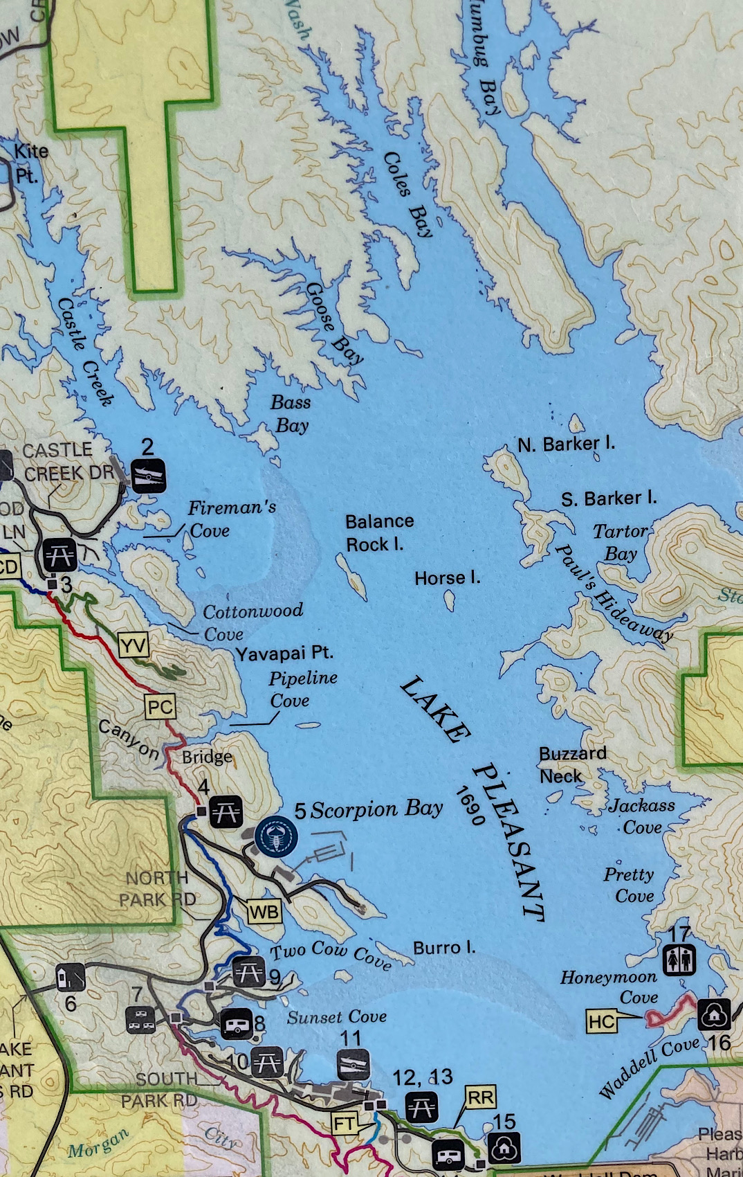
The next morning, we hop on our bikes and cycle 3.7 mi (6 km) up the road to the Pipeline Canyon Trail. Lake Pleasant Regional Park has almost 19 mi (30.5 km) of hiking trails ranging from 0.5 mile (0.8 km) to 4.4 mi (7 km) in length.
Our objective today is Yavapi Lookout off Pipeline Trail. Normally a floating bridge is installed in one section to connect the trails during high water. It wasn’t in yet, so we scrambled down a rough but clear path above the water and walked across to the main trail on the opposite side of the inlet.

From here it was an easy uphill zigzagging meander up to Yavapi Lookout with spectacular views of the lake – in total about a 2.5 mi (4 km) hike. Downhill bike ride all the way to our camp – yahoo!
Another sunset dinner, followed by a campfire and nightly parade of wild burros strolling along the park road in between our friends’ campsite and the washrooms.
Kayaking and Birding at Lake Pleasant
Day two saw us meeting up at the Castle Creek boat launch. With our friends settled in rental kayaks from Scorpion Bay Marina and us in our inflated double kayak, we headed out up Castle Creek Inlet.

Great blue herons and wild burros posed on the shore. Cormorants, buffleheads, mergansers, and gulls bobbed on the water ahead. A Harris hawk flew overhead. And of course, there were countless little, unidentified birds flitting around the lakeshore vegetation. Close to 130 bird species have been identified in the area.
Love birdwatching? Check out our Simple Snowbird Guide to Birding | Arizona post!

We passed a pair of stand up paddleboarders fighting a light head wind near Kite Point. Fishermen were anchored near shore testing their luck. Heading back past the launch we continued down to Fireman’s Cove, carrying the boats across a short 50 to 65 ft (15 – 20 m) isthmus exposed at low water and into Cottonwood Cove. Loading back up, we paddled back around to the Castle Creek boat launch. All in all it was a pleasant 4.1 mi (6.7 km) meander on the water.

One Last Short Interpretive Stroll
All too quickly our time was done. Meeting up with our pals in the morning, we strolled up from their campsite to check out the Discovery Centre. Unfortunately, it was closed so we weren’t about to check out the cultural and natural history exhibits, but we were able to take a walk down the Roadrunner interpretive trail to the Hohokam ruins.

Five different archaeological sites were found during an archaeological study of the Lake Pleasant area. These ruins are the only visible remains available for the public to see. According to the study, this area was occupied by the Hohokam people from A.D. 700 to 1450.
Next time we’ll plan ahead – need to note it in a “love to do” bucket list journal! – and stay a little longer and check out more of the off-the-beaten adventures in the hills beyond the park, perhaps following in the footsteps of eccentric female prospector Mollie Monroe in Castle Hot Springs.

As always, we’re heading off to a new locale with something left undone – a reason to come back again!
When You Go
To access the camping at Lake Pleasant from I-17 (Black Canyon Freeway), take Highway 74 (West Carefree Hwy) west for 11.5 mi (18.5 km) to the turnoff to Lake Pleasant Regional Park. Drive this road (North Castle Hot Springs Road) for a couple of miles to the park entrance. If you are driving in from U.S. 60 (Grand Avenue), head east on Highway 74 for 19 mi (30.5 km) to reach the turnoff of North Castle Hot Springs Road.
Love exploring Arizona’s lakes? Check out Alamo Lake State Park for your next RV adventure!

Leave a Reply